
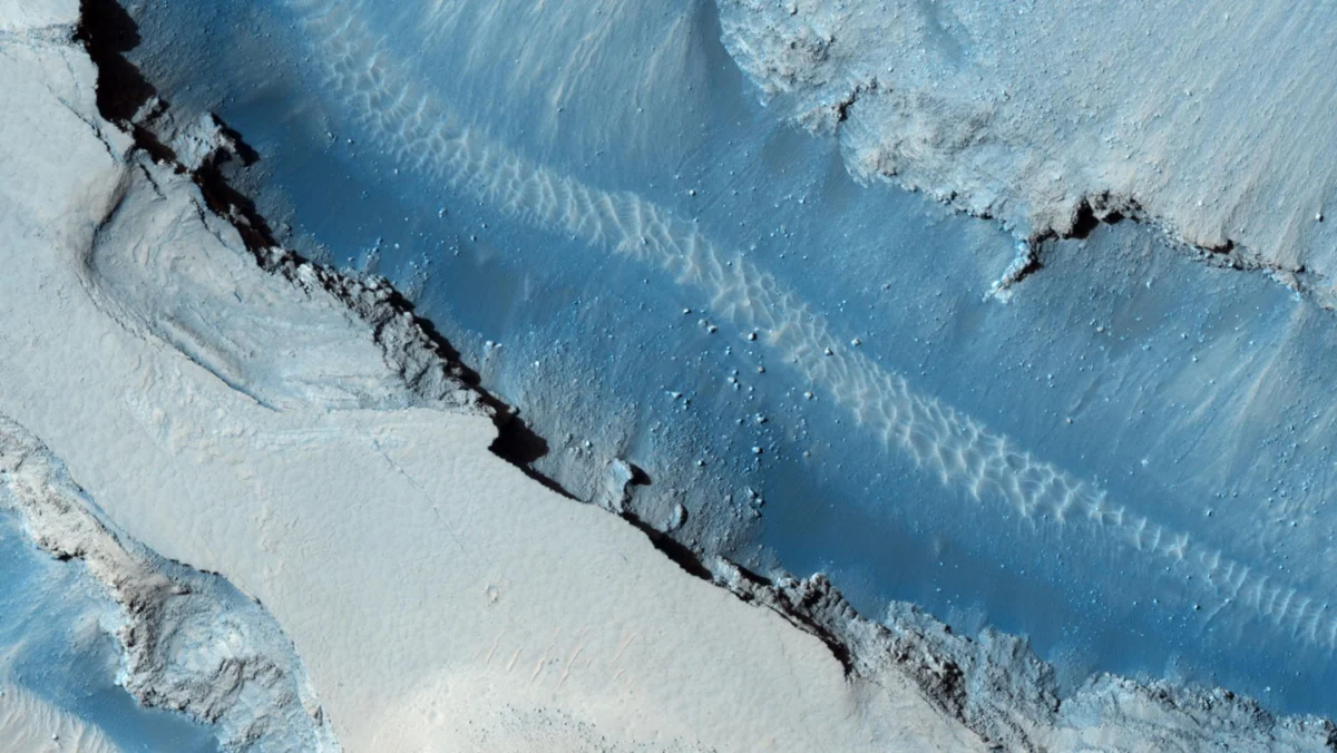
The surface of Mars, long perceived as a geologically dormant world, is proving to be far more active than early planetary models suggested. Recent analysis of high-resolution orbital imagery has provided compelling evidence that seismic activity—or "marsquakes"—is directly responsible for triggering large-scale rockfalls. Researchers studying the Cerberus Fossae region have identified hundreds of new, distinct tracks left by tumbling boulders, correlating these surface changes with seismic data captured by NASA’s InSight lander. This discovery not only confirms the mechanism behind mass wasting on the Martian surface but also establishes a new method for mapping planetary seismic hazards in regions where direct monitoring equipment is absent.
The Seismic Landscape of Cerberus Fossae
Cerberus Fossae is a system of dramatic fissures, cliffs, and deep valleys located just north of the Martian equator. It has long been a focal point for planetary scientists due to its youthful geological appearance, characterized by relatively recent volcanic and tectonic activity. Between 2018 and 2022, NASA’s InSight (Interior Exploration using Seismic Investigations, Geodesy and Heat Transport) lander provided an unprecedented look at the planet’s internal activity. During its operational lifespan, the lander’s sensitive seismometer detected more than 1,000 marsquakes, with a significant cluster originating from the Cerberus Fossae region.
The researchers, led by scientists at the Physical Research Laboratory in Ahmedabad, India, focused their investigation on a specific seismic event that occurred in July 2019. By performing a comparative analysis of orbital imagery—specifically high-resolution photographs taken in June 2019, just prior to the event, and December 2020, following the seismic tremors—the team uncovered 27 previously undocumented, linelike features along the canyon walls. These features, ranging from tens to hundreds of individual marks, are consistent with the path of a boulder bouncing and rolling down a steep incline.
Chronology of a Planetary Shift
The timeline of this discovery begins with the deployment of the InSight lander, which touched down on the Elysium Planitia in November 2018. For the duration of its mission, InSight served as the first dedicated seismometer on another planet, providing data that fundamentally changed the scientific community’s understanding of Martian interior structure.
In July 2019, the lander recorded a notable seismic disturbance originating in the vicinity of the Cerberus Fossae fissure system. While the tremor was significant enough to be detected by the lander’s sophisticated instrumentation, the physical manifestation of this event remained hidden until high-resolution orbital surveillance could provide the necessary before-and-after comparisons.
By comparing archival imagery with post-event data, the research team identified a sharp deviation from historical trends. Long-term statistical analysis of the region suggests that boulder falls are a sporadic, low-frequency occurrence, with an average rate of only two such features forming annually. The sudden emergence of 27 distinct tracks within an 18-month window represents a statistically significant anomaly, providing the "smoking gun" evidence that links the July 2019 marsquake to the physical displacement of surface materials.
Data and Analytical Implications
The study, published in the September 2 issue of npj Space Exploration, utilizes these rockfalls as a proxy for seismic activity. In terrestrial geology, earthquake-induced landslides are a well-documented phenomenon. Applying this principle to Mars allows researchers to map out historical seismic "hot spots" even in areas where an InSight-like lander was never present.
However, the findings also introduced a scientific puzzle that complicates current seismic models. Despite the widespread distribution of boulders on both the north and south sides of the Cerberus Fossae valleys, the fresh tracks were observed exclusively on the north-facing slopes. This spatial asymmetry suggests that the propagation of seismic waves on Mars may be influenced by complex local topography or subsurface geological structures that are not yet fully understood. As planetary scientist Vijayan noted, the way these waves traverse the Martian crust is likely highly irregular, meaning that the impact of a tremor can be localized and highly dependent on the specific structural integrity of the surrounding rock.
Official Perspectives and Scientific Consensus
The integration of seismic data with visual orbital evidence marks a shift toward "multi-messenger" planetary science. NASA’s Jet Propulsion Laboratory (JPL) and the broader InSight science team have consistently emphasized that Mars is not dead, but rather "tectonically twitchy."
For members of the research team, including seismologist Bivas Das, the results emphasize that the geological processes shaping Mars are ongoing. The unexpectedly high frequency of these boulder falls indicates that the Martian surface is in a constant state of flux, driven by internal energy that is still being released billions of years after the planet’s formation. This finding provides a necessary correction to the narrative that Mars is a static, museum-like environment.
Broader Impact on Future Exploration
As space agencies and private entities look toward the possibility of human exploration and eventual settlement on the Red Planet, the findings regarding boulder falls carry significant safety implications. Understanding the seismic stability of a region is a critical prerequisite for selecting landing sites and establishing long-term infrastructure.
If seismic activity can trigger rockfalls, then human habitats or scientific outposts placed near cliffs or unstable slopes could face significant risks. The use of boulder tracks as a "proxy" for seismic data offers a vital tool for mission planners. By observing the landscape for signs of recent mass wasting, scientists can effectively identify seismically active zones without needing to deploy expensive and power-hungry seismic arrays at every potential landing site.
Furthermore, these findings suggest that the "canary in the coal mine" approach could be scaled up. Using artificial intelligence to scan vast archives of orbital imagery could allow researchers to create global maps of Martian seismic activity. Such a map would be an invaluable asset for future mission architecture, helping to ensure that the locations chosen for human arrival are geologically stable and safe from the hazards of shifting terrain.
The Path Forward
The study of the Cerberus Fossae region underscores the necessity of continuous monitoring. While the InSight mission has concluded, the legacy of its data continues to yield discoveries that reshape our understanding of the solar system. The discovery of fresh boulder tracks is a testament to the power of cross-disciplinary research, blending seismology, remote sensing, and structural geology.
As researchers look ahead, the goal remains to better understand the internal mechanisms driving these tremors. Are they the result of cooling and shrinking of the planetary mantle, or is there residual volcanic activity beneath the Martian crust? The rockfalls themselves may hold the key to answering these questions. Each track is a physical record of an energy release that occurred millions of miles away. By cataloging these events, scientists are essentially building a seismic history of the planet, one boulder at a time.
In the broader context of space exploration, this discovery serves as a reminder that Mars remains a dynamic, evolving world. The risks associated with its seismic environment are now better understood, and the methods developed to identify these risks are proving to be both effective and essential. As the international community prepares for the next phase of Martian exploration, the data derived from the Cerberus Fossae study will undoubtedly form a core component of the safety protocols and site-selection criteria for the next generation of robotic and human explorers. The tracks left behind by these falling boulders are not merely geological curiosities; they are markers of a planet that is still very much alive, providing a roadmap for those who hope to one day walk its surface.