
The Pacific Ocean is currently experiencing an El Niño event of unprecedented intensity, shattering historical temperature records and signaling a shift in global weather dynamics that experts warn could have profound consequences for human health, agriculture, and infrastructure. Data derived from the European Union’s Copernicus Marine Service confirms that sea surface temperatures across the equatorial Pacific have reached levels never before observed in the modern instrumental record. This surge in thermal energy is not merely a localized phenomenon; it serves as a massive catalyst, accelerating the release of latent heat into the atmosphere and disrupting long-established meteorological patterns across the globe.
A Chronology of Intensification
The trajectory toward this record-breaking event began in early 2026, when subsurface ocean temperatures in the Pacific began to exhibit anomalies that diverged significantly from historical baselines. By late spring, oceanographers and climatologists identified the rapid transition from neutral conditions to a robust El Niño state. Unlike previous events, which often saw a gradual build-up, the current cycle demonstrated a rapid, aggressive expansion of the “warm pool”—a massive swath of heated water extending from the central Pacific toward the coast of South America.
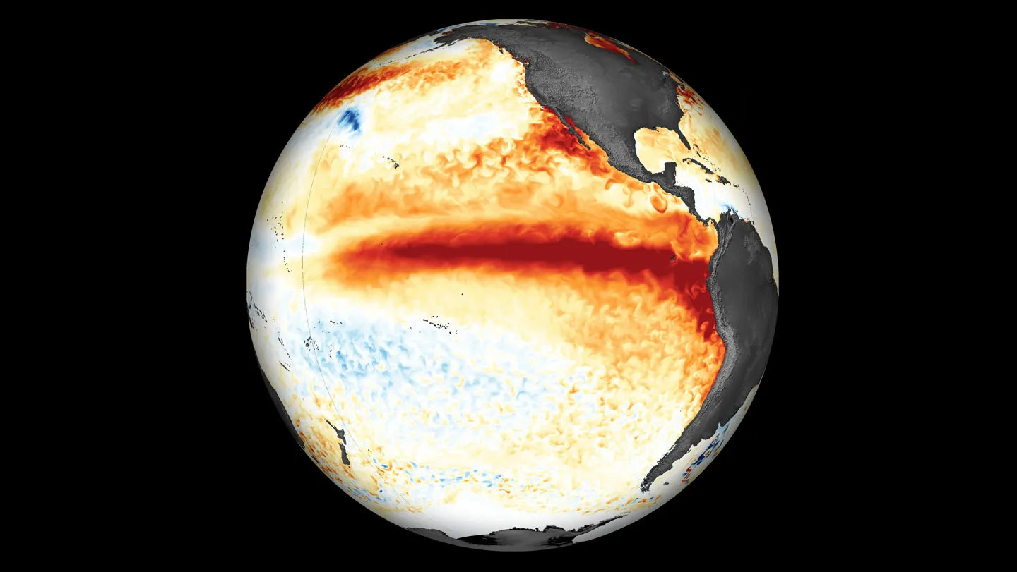
By August 25, satellite telemetry provided by the Copernicus Marine Service captured a distinct, continuous “slash” of warmer-than-normal sea surface temperatures. This visual representation underscored the magnitude of the thermal buildup, as the heat plume began to exert pressure on atmospheric circulation patterns. Throughout September, the anomaly continued to widen, defying models that suggested a more moderate progression. As of the latest reporting, the event has transitioned from a developing climate anomaly to a full-scale, "super" El Niño, forcing meteorological agencies worldwide to revise their seasonal outlooks to reflect the heightened volatility.
The Mechanics of an El Niño Super-Event
El Niño, or the warm phase of the El Niño-Southern Oscillation (ENSO), is a cyclical climate phenomenon defined by the weakening of trade winds that typically push warm surface water toward Indonesia and Australia. When these winds falter, the accumulated warm water surges eastward toward the Americas.
The current event is distinguished by its sheer thermal capacity. The ocean acts as a massive heat sink; when surface temperatures deviate from the norm by several degrees Celsius across such a vast expanse, the atmosphere responds with equal intensity. The primary mechanism driving this record-breaking heat is the combination of the natural ENSO cycle layered upon a background of long-term global ocean warming driven by anthropogenic climate change. This “double-loading” effect has allowed the current event to transcend the thresholds set by the 1997-1998 and 2015-2016 super El Niños, both of which were previously considered the benchmarks for extreme climate behavior.
Supporting Data and Meteorological Indicators
Climatological data from the past six months paints a stark picture of the current state of the Pacific. Sea surface temperature (SST) anomalies in the Niño 3.4 region—the primary metric used to classify the intensity of the event—have consistently remained above the threshold for "strong" and "very strong" categorizations.
Furthermore, the Multivariate ENSO Index (MEI), which integrates sea level pressure, surface winds, and surface air temperatures, indicates that the current atmospheric coupling is exceptionally tight. This means that the ocean and the atmosphere are communicating their energy states more efficiently than in weaker events, leading to a more rapid propagation of weather anomalies. While historical records from the mid-20th century provide a baseline, this 2026 event marks the first time that satellite-era observations have recorded such a consistent and sustained peak in thermal energy, suggesting that the "new normal" for these events has been fundamentally altered.
Global Implications: From Droughts to Deluges
The implications of an El Niño of this magnitude are far-reaching, with direct impacts on global food security and public safety. Historically, El Niño events are associated with a shift in the jet stream, which alters storm tracks across North and South America.
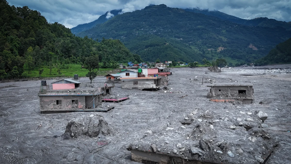
In the United States, regions in the South and Southwest are bracing for significantly increased precipitation, which, while potentially alleviating long-term drought, poses a high risk of catastrophic flash flooding and landslides. Conversely, parts of the Pacific Northwest and Canada often experience milder, drier winters, which can complicate water management and heighten the risk of extended wildfire seasons in the subsequent year.
The global south faces even more acute challenges. Southeast Asia, Australia, and parts of Southern Africa often experience severe drought during strong El Niño cycles. With global commodity markets already strained, the prospect of reduced crop yields in these regions—particularly for staples like rice, wheat, and soy—poses a significant risk of inflationary pressure on food prices. Furthermore, the increased heat content in the upper layers of the ocean serves as an engine for tropical cyclones. While El Niño often increases wind shear in the Atlantic, which can suppress hurricane formation, it simultaneously creates highly favorable conditions for more frequent and intense typhoons in the Pacific basin, threatening coastal populations from Japan to the Philippines.
Scientific and Official Responses
International meteorological agencies, including the World Meteorological Organization (WMO) and the U.S. National Oceanic and Atmospheric Administration (NOAA), have issued recurring bulletins urging governments to prepare for extreme weather volatility. The consensus among the scientific community is that this event is a "beast"—a term that has migrated from informal warnings to professional discourse due to the unpredictability and violence of the atmospheric responses observed thus far.
"The data is unequivocal," noted one researcher familiar with the Copernicus reports. "We are seeing a departure from the historical distribution of ENSO events. The ocean is not just warmer; it is holding more energy than our previous models accounted for. We are effectively entering a phase where the extreme becomes the baseline."
Governmental bodies in affected regions have begun activating emergency response protocols. In Peru and Ecuador, where the impacts of El Niño are felt most acutely due to the immediate proximity of the warm water, authorities are prioritizing infrastructure fortification to protect against inevitable flooding. In the United States, FEMA and other agencies are coordinating with local municipalities to ensure that emergency stocks of food, fuel, and medical supplies are positioned for a winter that is expected to be marked by extreme storm activity.
Analysis of the Long-Term Climate Context
The current El Niño serves as a diagnostic tool for the broader health of the planet’s climate system. While ENSO is a natural oscillation, the intensity of this specific event highlights how human-induced climate change is magnifying the effects of natural variability. As the global ocean continues to absorb more than 90 percent of the excess heat trapped by greenhouse gas emissions, the “baseline” temperature of the Pacific has risen. Consequently, when an El Niño event occurs, it starts from a higher thermal floor, allowing it to reach record-breaking intensities with less atmospheric effort.
This phenomenon raises critical questions for climate policy and urban planning. Infrastructure designed in the 20th century was calibrated to handle historical norms of temperature and precipitation. The 2026 super El Niño demonstrates that those norms are no longer reliable indicators of future risk. From urban drainage systems capable of handling "100-year floods" occurring every few years, to agricultural practices that rely on stable seasonal rainfall, society is being forced to adapt to a reality where the extreme is the new standard.
Concluding Outlook
As the world heads into the final quarter of 2026, the focus remains on the persistence of the anomaly. Meteorological models suggest that the peak intensity may continue through the winter months, potentially extending into early 2027. The global scientific community will continue to monitor the Pacific with unprecedented scrutiny, utilizing advanced satellite arrays and buoy networks to track every shift in the ocean’s thermal state.
The record-breaking nature of this El Niño is not merely a statistical curiosity; it is a clear warning sign. The convergence of historical patterns and modern climate reality has created a scenario where the environment is capable of rapid, high-impact changes. For policymakers, researchers, and the general public, the mandate is clear: the era of climate stability is giving way to a period of heightened volatility, requiring a global commitment to resilience, adaptive infrastructure, and robust, data-driven preparedness. The current record-breaking Pacific temperatures are the latest chapter in a rapidly unfolding climate narrative, one that will define the challenges of the coming decade.