
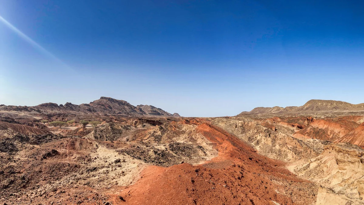
The continent won’t split anytime soon. But the thinning is a critical transition. The Earth’s crust, a mosaic of colossal tectonic plates, is in a constant, slow-motion dance, shaping continents and oceans over eons. In eastern Africa, this grand geological ballet has reached a pivotal, yet gradual, stage: a significant thinning and fracturing of the continental plate, a process that scientists are closely observing as it portends a future, albeit distant, continental breakup. The Turkana Rift Zone, spanning parts of Kenya and Ethiopia, stands as a stark visual testament to these immense subterranean forces, its arid, fractured landscape a testament to the Earth’s dynamic crust.
The Anatomy of a Continental Tear
The phenomenon unfolding in East Africa is known as continental rifting, a process where tectonic forces pull the Earth’s lithosphere apart. This stretching thins the crust, leading to faulting and the formation of rift valleys, often accompanied by volcanic activity. The East African Rift System (EARS) is one of the most active and well-studied continental rifts on Earth, stretching for thousands of kilometers from the Red Sea and Gulf of Aden in the north, through Ethiopia, Kenya, Uganda, Tanzania, and into Mozambique.
The Turkana Rift Zone, a segment of the EARS, is particularly significant due to its pronounced thinning and active geological processes. Here, the continental crust is being stretched and fractured, creating a series of valleys, volcanoes, and lakes, the most prominent being Lake Turkana, a vast alkaline lake. This geological activity is driven by the divergent movement of the African Plate, which is in the process of splitting into two smaller plates: the Nubian Plate to the west and the Somali Plate to the east. While this separation is happening at a glacial pace, measured in millimeters per year, the concentrated forces in regions like the Turkana Rift are accelerating the localized effects of this tectonic strain.
A Gradual Genesis: Timeline of a Continental Divide
The forces driving the East African Rift System have been at play for millions of years, but the current phase of intense rifting is thought to have begun around 25 million years ago. The earliest signs of this continental separation manifested as volcanic activity and the formation of broad upwarps in the Earth’s crust.
Over millions of years, these upwarps began to stretch and thin, leading to the formation of elongated depressions – the rift valleys. The Turkana Rift Zone, as it is recognized today, has seen significant development within the last few million years. Evidence from geological surveys and seismic imaging reveals a complex network of faults and volcanic structures that have developed as the crust has been pulled apart.
- Miocene Epoch (23 to 5.3 million years ago): Initial stages of rifting, characterized by widespread volcanism and the formation of broad basins.
- Pliocene Epoch (5.3 to 2.6 million years ago): Intensification of rifting, leading to the development of distinct rift valleys and increased faulting. Volcanic activity continued, shaping the landscape.
- Pleistocene Epoch (2.6 million years ago to 11,700 years ago): Further deepening and widening of the rift valleys. The formation of the Great Lakes of East Africa, including Lake Turkana, became more pronounced. Human evolution also occurred within this dynamic geological setting.
- Holocene Epoch (11,700 years ago to present): Continued, albeit slow, rifting and tectonic activity. Modern geological processes, including seismic events and volcanic eruptions, are observed. The Turkana Rift Zone is a focal point of current research due to its accelerated thinning.
Scientists are able to reconstruct this timeline through various geological dating methods, including radiometric dating of volcanic rocks and the analysis of sedimentary layers within the rift valleys. These methods provide crucial insights into the rate and progression of the rifting process.
Data Unveiling the Earth’s Thinning Skin
Geophysical studies employing satellite geodesy, seismic tomography, and ground-based measurements have provided compelling data on the extent and nature of the thinning occurring in the Turkana Rift Zone.
Crustal Thickness: Studies have indicated that the crust in the Turkana region is significantly thinner than the average continental crust. While typical continental crust can range from 30 to 50 kilometers in thickness, measurements in the Turkana Rift suggest thicknesses as low as 15-20 kilometers in certain areas. This thinning is a direct consequence of the stretching and extension of the lithosphere.
Deformation Rates: High-precision GPS measurements reveal that the land surface in the Turkana Rift is stretching at rates of several millimeters per year. This measured deformation confirms the ongoing tectonic activity and the concentrated forces at play in this region. For instance, research has documented extension rates of up to 5-7 millimeters per year across some segments of the rift.
Seismic Activity: The Turkana Rift Zone experiences moderate seismic activity, with frequent earthquakes. These seismic events are indicative of the fracturing of the crust as it is pulled apart. While most earthquakes are relatively small, their distribution and depth provide valuable information about the subsurface stress and fault systems. Seismological networks in the region continuously monitor these events, helping to map out the active fault lines.
Volcanic Provinces: The thinning of the crust also reduces the pressure on the underlying mantle, allowing magma to rise to the surface. The Turkana Rift Zone is characterized by a series of Quaternary volcanoes, indicating ongoing magmatic activity associated with the rifting process. This volcanic activity is not only a direct consequence of the thinning but also contributes to the reshaping of the landscape.
Reactions and Interpretations: A Scientific Consensus
The scientific community widely agrees that the East African Rift System, and specifically the Turkana Rift Zone, represents a significant geological event in progress. Leading geoscientists and institutions specializing in plate tectonics and geophysics are actively involved in studying the region.
Dr. Sarah Davies, a geophysicist at the University of Nairobi, commented, "The Turkana Rift is a natural laboratory for understanding continental breakup. The data we are collecting, from satellite measurements to seismic surveys, paints a clear picture of a continent undergoing profound transformation. While the timescale for complete separation is vast, the processes at play are undeniable and offer a unique opportunity to study the Earth’s dynamic processes in real-time."
The collaborative nature of research in the region means that data is often shared and analyzed by international teams. Organizations like the Geological Society of Africa and various university research departments are publishing findings that consistently support the interpretation of an ongoing continental split. The implications of this research extend beyond understanding plate tectonics, influencing hazard assessments and resource exploration in the region.
Broader Impact and Implications: A Continent Reshaped
The ongoing rifting in East Africa, while a slow-moving geological process, carries significant implications for the region and for our understanding of Earth’s evolution.
Future Geography: The ultimate consequence of this continental breakup, if it continues to completion over tens of millions of years, would be the formation of a new ocean basin. A new sea could eventually separate the Nubian and Somali plates, fundamentally altering the geography of Africa and creating new coastlines. This process, however, is not guaranteed; rifting can also cease or evolve into other tectonic settings.
Environmental and Climatic Shifts: The formation of rift valleys and the associated volcanic activity can influence regional climate patterns. The creation of topographic barriers can alter atmospheric circulation, and the presence of large lakes can affect local humidity and rainfall. Over geological timescales, these changes can lead to shifts in ecosystems and biodiversity.
Geothermal Energy Potential: The thinning of the crust and the proximity of magma chambers make regions like the Turkana Rift Zone prime candidates for geothermal energy development. Countries in East Africa are actively exploring and utilizing this renewable energy source, which is directly linked to the tectonic activity of the rift system. Ethiopia, for example, has made significant strides in harnessing its geothermal potential.
Seismic and Volcanic Hazards: While the breakup is a long-term prospect, the ongoing tectonic activity poses immediate hazards. Earthquakes and volcanic eruptions, though not always catastrophic, can have significant impacts on local populations and infrastructure. Understanding the fault lines and volcanic systems is crucial for disaster preparedness and mitigation efforts.
Human Evolution and Migration: The dynamic geological landscape of East Africa has played a role in human evolution. The varied environments created by the rift system, including the emergence of lakes and savannahs, may have provided diverse ecological niches that influenced early hominin adaptation and migration.
In conclusion, the Turkana Rift Zone serves as a dramatic illustration of plate tectonics in action. While the vision of a sundered continent remains a distant geological future, the thinning and fracturing of Africa’s crust is a profound and ongoing transition. The meticulous scientific observation and analysis of this process not only deepen our understanding of planetary dynamics but also offer insights into the potential future of our planet and the regions directly affected by these immense subterranean forces. The continent may not be splitting "anytime soon," but the critical transition it is undergoing is a testament to the Earth’s ceaseless, transformative power.


Leave a Reply